FRIENDS OF THE BAY INC
  • About Us
    • Who We Are
    • Projects
    • 2024 SUPPORTERS
    • Contact Information
    • Board Members, Advisory Board, and Staff
    • Achievement Timeline
    • FOB History
  • Monitoring
    • Unified Water Study
    • Water Quality Data
    • Annual Water Quality Reports
    • State of the Watershed
    • Watershed Action Plan
    • Quality Assurance Project Plan
  • Events
  • News
    • News >
      • News Archive
    • Media Center >
      • Social Media
      • Photo Gallery
      • Tunnel
      • Maps
    • FOB Statements & Op-Eds
    • Newsletter
  • Donate Today
  • Get Involved
    • Volunteer Opportunities
    • Terrapin Monitoring
    • ADVOCACY ALERTS
    • Membership
    • Coastal Cleanup Crew
    • Team-Building Beach Cleanups
    • Beach Cleanup Stations
  • Resources
    • Resources & Links
    • Story Maps
    • Partner Organizations
    • Local Wildlife >
      • Diamonback Terrapins
      • Horseshoe Crabs >
        • Horseshoe Crab Protection Act
        • Horseshoe Crab Protection Act Letter of Support
        • Horseshoe Crab Postcards
    • "Did you know..."
    • History of the Watershed
    • About Oyster Bay/cold Spring Harbor
  • Online Store
HOME PAGE

Water Quality Data

Interested in Viewing data around the Long Island Sound?

Friends of the Bay was proud to be one of the first groups to contribute data to a new data sharing platform developed by Save the Sound called QuickDrops. QuickDrops is the first database of its kind designed to collect, manage, and broadly share water quality data specific to the Long Island Sound watershed. Check out data from all around the sound by creating a free account at quickdrops.org

Pathogen Monitoring

One of the questions we get asked most often is, "How clean is the water in Oyster Bay?" Bacteria levels play a major role in providing an answer to that question. At Friends of the Bay we measure the number of coliform bacteria and enterococci around Oyster Bay's waters.

We currently take water samples every other week from May through October at 14 open-water sites and ten tributary/outfall sites from Lattingtown to Cold Spring Harbor. We bring those samples to the Nassau County Deprtment of Health where they are tested for enterococci and fecal coliform bacteria.


Below is a map of enterococci bacteria data with low, medium and high bacteria color coding so it is easy to see how bacteria levels vary within our bay and watershed. This map will be updated approximately every two weeks when we take new samples.
See the current and previous maps by clicking on the arrows or icons below

Site Locations 

Stream and Outfall sites ▲
Open Water Sites ​●
▲ Spring Street Outfall, Cold Spring Harbor 
▲ Cold Spring Harbor Hatchery, Cold Spring Harbor

▲ Mill Pond Headwaters, Oyster Bay 
▲ White’s Creek Outfall, Oyster Bay  

▲ Beekman Beach Outfall, Oyster Bay
▲ Adams Avenue Outfall, Bayville
▲ Tributary at Meudon Drive and Parish Drive, Lattingtown
▲ Frost Creek Drive Bridge, Lattingtown
▲ Creek Club, Lattingtown
​▲ Sheep Lane Bridge at Frost Creek, Lattingtown

● Cold Spring Cove South, Cold Spring Harbor
● Cold Spring Cove North, Cold Spring Harbor
● Cold Spring Beach North, Cold Spring Harbor
● Cold Spring Harbor South, Cold Spring Harbor
● Laurel Hollow, Cold Spring Harbor
● Lloyd Beach, Cold Spring Harbor
● Centre Island North, Cold Spring Harbor
● Moses Point, Oyster Bay
● Roosevelt Beach, Oyster Bay
● West Harbor, Oyster Bay
● Turtle Cove, Oyster Bay
● Creekview, Mill Neck Creek
● Mill Neck Creek East, Mill Neck Creek
● Mill Neck Creek West, Mill Neck Creek
​Coliform bacteria are an accumulation of different bacteria species, including both fecal and non-fecal bacteria. The fecal coliform bacteria are found in the intestines of warm-blooded animals, some fecal coliform species are disease-causing. When fecal coliform is present in water bodies it indicates possible contamination from human or animal fecal matter.

Enterococci are a different type of fecal bacteria found in warm-blooded animal intestines. They are a subgroup of fecal streptococcus that can live in salt water. Enterococci is an indicator organism at shellfish harvesting areas and coastal beaches. We use both types of bacteria as water quality indicators. 

Bacteria levels can fluctuate throughout different areas of Oyster Bay, Mill Neck Creek and Cold Spring Harbor depending on rainfall, the amount of runoff entering the water and the amount of tidal flushing. Bacteria levels can vary geographically, especially in areas of the bay bordered by streams or outfall pipes.

When a beach is closed for swimming after a heavy rainfall, it is because bacteria levels are too high, and it is a good idea to wait 48 hours before going swimming. Swimming standards are set by New York State and if enterococci levels are above 104 cfu (colony forming units) per 100 millileters it is unsafe to swim.
Friends of the Bay received a Quality Assurance Project Plan from the Environmental Protection Agency in April of 2006 and was later updated in June 2020.  Friends of the Bay has a long-standing water quality monitoring program which began in the late 1990s.  Data from 2005 and earlier is available upon request.

Since the late 1990s. Friends of the Bay ran its own core water quality monitoring program which included sampling for pathogens. Since 2017 we have been participating in the Unified Water Study. To avoid redundancy we concluded our core monitoring program in 2024 and became fully invested in the Unified Water Study while still maintaining the pathogen monitoring part of our core program.

2024 Data:

See the previous maps by clicking on the arrows or icons below

Site Locations 

Stream and Outfall sites ▲
Open Water Sites ​●
▲ Spring Street Outfall, Cold Spring Harbor 
▲ White’s Creek Outfall, Oyster Bay  
▲ Beekman Beach Outfall, Oyster Bay
▲ Adams Avenue Outfall, Bayville
▲ Tributary at Meudon Drive and Parish Drive, Lattingtown
▲ Frost Creek Drive Bridge, Lattingtown
▲ Creek Club, Lattingtown
​▲ Sheep Lane Bridge at Frost Creek, Lattingtown

● Cold Spring Cove South, Cold Spring Harbor
● Cold Spring Cove North, Cold Spring Harbor
● Cold Spring Beach North, Cold Spring Harbor
● Cold Spring Harbor South, Cold Spring Harbor
● Laurel Hollow, Cold Spring Harbor
● Lloyd Beach, Cold Spring Harbor
● Centre Island North, Cold Spring Harbor
● Moses Point, Oyster Bay
● Roosevelt Beach, Oyster Bay
● West Harbor, Oyster Bay
● Turtle Cove, Oyster Bay
● Creekview, Mill Neck Creek
● Mill Neck Creek East, Mill Neck Creek
● Mill Neck Creek West, Mill Neck Creek

Use this map of pathogen monitoring sites to navigate historic pathogen results given below 

2023 Data:

2023 water quality monitoring raw data
Bacteria Monitoring Levels in 2023 at Friends of the Bay's 8 Sampling Stations 
Picture
Picture

2022 Data:

2022 water quality monitoring raw data
Bacteria Monitoring Levels in 2022 at Friends of the Bay's 8 Sampling Stations ​
Picture
Picture
Data archives can be found at the bottom of this page 

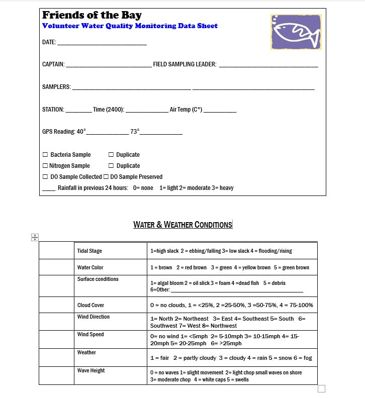
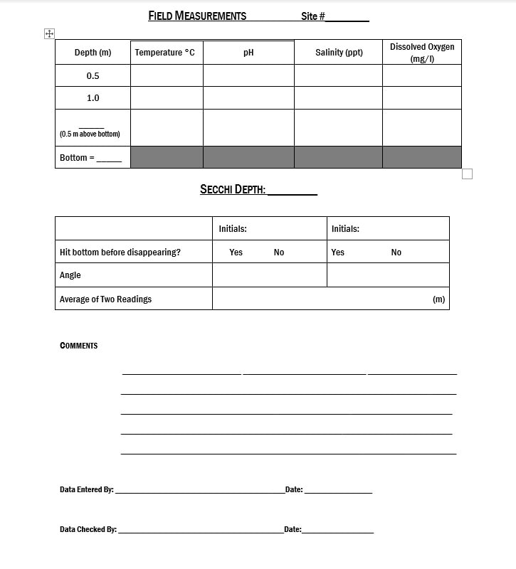
Water Quality Monitoring Data Sheet – This is the sheet used by Friends of the Bay water quality monitors. Use this sheet to interpret the ambient readings recorded for wind, weather, tide, etc.

Picture
Picture
Click here to dowload a PDF of the data sheet

Data Archives
​
​Note: Click on link to download PDF

2021 water quality data
2020 water quality data 
2019 Water Quality Data 
2018 Water Quality Data
2017 Water Quality Data
2016 Water Quality Data
2015 Water Quality Data 
2014 Water Quality Data
2013 Water Quality Data
2012 Water Quality Data
2011 Water Quality Data
2010 Water Quality Data
2009 Water Quality Data
2008 Water Quality Data
2007 Water Quality Data
2006 Water Quality Data
Picture
501(c)(3) nonprofit organization
CONTACT US​
111 South Street, Suite 210​
Oyster Bay, NY 11771​
​516-922-6666

​[email protected]
​© Friends of the Bay. All rights reserved.
  • About Us
    • Who We Are
    • Projects
    • 2024 SUPPORTERS
    • Contact Information
    • Board Members, Advisory Board, and Staff
    • Achievement Timeline
    • FOB History
  • Monitoring
    • Unified Water Study
    • Water Quality Data
    • Annual Water Quality Reports
    • State of the Watershed
    • Watershed Action Plan
    • Quality Assurance Project Plan
  • Events
  • News
    • News >
      • News Archive
    • Media Center >
      • Social Media
      • Photo Gallery
      • Tunnel
      • Maps
    • FOB Statements & Op-Eds
    • Newsletter
  • Donate Today
  • Get Involved
    • Volunteer Opportunities
    • Terrapin Monitoring
    • ADVOCACY ALERTS
    • Membership
    • Coastal Cleanup Crew
    • Team-Building Beach Cleanups
    • Beach Cleanup Stations
  • Resources
    • Resources & Links
    • Story Maps
    • Partner Organizations
    • Local Wildlife >
      • Diamonback Terrapins
      • Horseshoe Crabs >
        • Horseshoe Crab Protection Act
        • Horseshoe Crab Protection Act Letter of Support
        • Horseshoe Crab Postcards
    • "Did you know..."
    • History of the Watershed
    • About Oyster Bay/cold Spring Harbor
  • Online Store